Maps
Maps
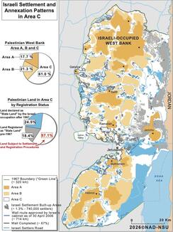
This map illustrates land classification in the Oslo-defined Area "C" of the West Bank, in the context of Israeli Government Resolution No. 3559 from February...
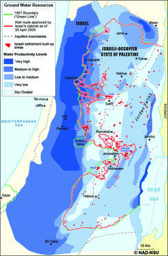
The map shows the spatial zones of groundwater productivity of the three shared groundwater basins; the Eastern Basin: The Northeastern Basin, and the Western...
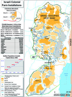
This map illustrates the Israeli Colonial Farm Installations (outposts) in the West Bank: A total of 793,909 dunums, approximately 14% of the...
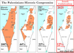
Israel's illegal land theft and annexation of occupied Palestinian lands deny the national rights of the people of Palestine and render the...
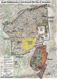
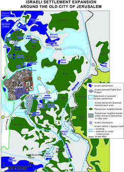
The Israeli settlements established by extremist Jewish settler groups in the Palestinian communities in the Old City are not only illegal under international...
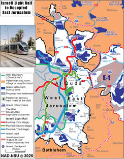
This map illustrates the routes of the Jerusalem Light Rail (JLR) which is an Israeli government project designed to link illegal Israeli settlements in the...

The map highlights the scale of Israel’s annexation strategy in the occupied West Bank. Today, approximately 740,000 Israeli settlers live in settlements...
This map illustrates the increasing Israeli settlement activity in and around occupied Jerusalem under the current Israeli government. The current government...

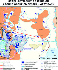
The maps illustrate how Israel's colonial settlement enterprise aims to limit the potential for developing the Eastern and southern gateways to occupied...